Tuesday, August 20, 2013

FROM the eyes of DR AJAY KUMAR OJHA: BAKHARI BAZAR VILLAGE OF THARUHAT (WEST CHAMPARAN, BIHAR, INDIA)

A GLIMPSE OF BAKHARI  BAZAR VILLAGE 
OF THARUHAT (WEST CHAMPARAN, BIHAR)

June 2013


(All the images are subject to IPR)


A Bridge  before Bakhari Bazar
& Dr Ajay Kumar Ojha


View of a Farm  in Tharuhat
Photo (c) Dr Ajay Kumar Ojha


Canal  on the way to Bakhari Bazar
Road on its bank goes to Balmikinagar
Photo (c) Dr Ajay Kumar Ojha


Yogendra Mahto(Tharu) in the middle alongwith another Tharu of Bakhari Bazar 
interacting with a non-Tharu
Photo (c) Dr Ajay Kumar Ojha


DTH reaches in Bakhari Bazar
Photo (c) Dr Ajay Kumar Ojha


Bakhari Bazar Chowk on Ramnagar-Gobardhana road
Photo (c) Dr Ajay Kumar Ojha


One of the oldest Medical shops in Bakhari Bazar
[(Ramchandra Khatait (Tharu) with Jitendra Mahato(Tharu)]
Photo (c) Dr Ajay Kumar Ojha


Bakhari  Bazar Chowk
Photo (c) Dr Ajay Kumar Ojha


Gobardhana 4.50 KM from Bakahri Bazar
Photo (c) Dr Ajay Kumar Ojha


Bakhari Bazar Chowk 
Photo (c) Dr Ajay Kumar Ojha


Solar Panel  being used in Bakhari Bazar
Photo (c) Dr Ajay Kumar Ojha


Ramnagar-Gobardhana road touching Bakhari Bazar
Photo (c) Dr Ajay Kumar Ojha


Primary Health Centre (PHC) in Bakhari Bazar
Photo (c) Dr Ajay Kumar Ojha


Sunday, August 4, 2013

FROM the eyes of DR AJAY KUMAR OJHA : CHANAKIGARH (WEST CHAMPARAN, BIHAR)

FROM the eyes of DR AJAY KUMAR OJHA :

CHANAKIGARH (WEST CHAMPARAN, BIHAR)


(All the images are subject to IPR)


 Structures  like Nandangarh (Lauria ) have also been located near Narkatiaganj at Chankigarh.


Photo (c) Dr Ajay Kumar Ojha


It is believed to be the remains of palaces of Nanda Dynasty and Chanakya, well known for his 'Arthashastra', a dooctrine on governance and economic affairs.


Photo (c) Dr Ajay Kumar Ojha


The great emperor Chandragupta Maurya is also supposed to have been born somewhere here.


Photo (c) Dr Ajay Kumar Ojha


Photo (c) Dr Ajay Kumar Ojha


)

Saturday, August 3, 2013

FROM the eyes of DR AJAY KUMAR OJHA : KESARIA STUPA, EAST CHAMPARAN , BIHAR


FROM the eyes of DR AJAY KUMAR OJHA : 
KESARIA STUPA ( EAST CHAMPARAN ,  BIHAR)

                                                        (All the images are subject to IPR)
Kesariya is a town in BiharIndia in the district of East Champaran, near Rampur Khajuria on NH28 on the eastern bank of River Gandak (Narayani). It is the site of a stupa built by the King Ashoka. It is one of, if not the largest stupa in India. The Buddha once stayed in Kesariya (then called "Kesaputta"). On that occasion, he preached the Kesaputtiya Suttas which include the Kalama Sutta. The inhabitants of Kesariya were the Kosalans and the Kalamas.


National Highway 28
Photo (c) Dr Ajay Kumar Ojha


Photo (c) Dr Ajay Kumar Ojha


Photo (c) Dr Ajay Kumar Ojha


Kesaria claims the tallest and the largest Buddhist Stupa in the world. The stupa was discovered in 1998 during an excavation by the Archaeological Survey of India (ASI). The stupa dates to between 200 AD and 750 AD and may have been associated with the 4th century ruler, Raja Chakravarti.


Photo (c) Dr Ajay Kumar Ojha


Photo (c) Dr Ajay Kumar Ojha


At 104 feet, Kesaria Stupa is one foot taller than the Borobodur Stupa in Java. It is also taller than the second largest stupa at Ghorakatora in the Nalanda district. The National Informatics Centre of East Champaran (Motihari) suggests the Kesaria Stupa was 123 feet tall before the 1934 earthquake in Bihar. According to a report by the A.S.I., the Kesaria Stupa was originally 150 feet in height. The height of Sanchi Stupa a world heritage site is 77.50 feet.


Photo (c) Dr Ajay Kumar Ojha


In ancient times Kesariya was under the rule of the Mauryas and the Lichchhavis. Recent discovery ( during excavations for canals) of gold coins embossed with the seal of the Emperor Kanishka of the Kushan dynasty, confirms the ancient heritage of Kesariya. The Chinese traveller Fa-Hien had come to Kesariya, in the course of his visit to India during the Gupta Period. Later, impressed by Kesariya's geographic location and its cultural activities, another Chinese traveller, Huen-Sang also visited this place. In the accounts of his travels, he has mentioned at length about Kesariya.


(Input courtesy :wikipedia.org)


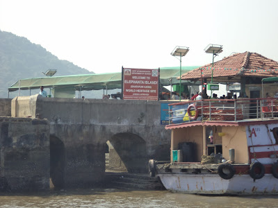
FROM the eyes of DR AJAY KUMAR OJHA : GHARAPURI OR ELEPHANTA ISLAND (UNESCO WORLD HERITAGE SITE)


FROM the eyes of DR AJAY KUMAR OJHA :
 GHARAPURI OR ELEPHANTA ISLAND
(UNESCO World Heritage Site)

(All the images are subject to IPR)
Hotel Taj & Gateway Of India
Photo(c) Dr Ajay Kumar Ojha


Photo (c) Dr Ajay Kumar Ojha


Photo (c) Dr Ajay Kumar Ojha


Photo (c) Dr Ajay Kumar Ojha


Photo (c) Dr Ajay Kumar Ojha


The Elephanta Caves are a network of sculpted caves located on Elephanta Island, or Gharapuri(literally "the city of caves") in Mumbai Harbour, 10 kilometres to the east of the city of Mumbai in the Indian state of Maharashtra. The island, located on an arm of the Arabian Sea, consists of two groups of caves—the first is a large group of five Hindu caves, the second, a smaller group of two Buddhist caves. The Hindu caves contain rock cut stone sculptures, representing the Shaiva Hindu sect, dedicated to the god Shiva.


Photo (c) Dr Ajay Kumar Ojha


Gharapuri Island in background
Photo(c) Dr Ajay Kumar Ojha


Photo (c) Dr Ajay Kumar Ojha


Toy Train for Gharapuri Island
Photo (c) Dr Ajay Kumar Ojha


The rock cut architecture of the caves has been dated to between the 5th and 8th centuries, although the identity of the original builders is still a subject of debate. The caves are hewn from solid basalt rock. All the caves were also originally painted in the past, but now only traces remain.


Photo (c) Dr Ajay Kumar Ojha


Photo (c) Dr Ajay  Kumar Ojha


Photo (c) Dr Ajay Kumar Ojha


Photo (c) Dr Ajay Kumar Ojha


The island was called Gharapuri and was a Hindu place of worship until Portuguese rule began in 1534. The Portuguese called the island Elephanta on seeing its huge gigantic statue of an Elephant at the entrance. The Statue is now placed in the garden outside the Bhau Daji Lad Museum at the Jijamata Udyaan  at Byculla in Mumbai. This cave was renovated in the 1970s after years of neglect, and was designated a UNESCO World Heritage Site in 1987 to preserve the artwork. 


An Unfinished Buddhist Cave
Photo (c) Dr Ajay Kumar Ojha


 The island covers about 4 square miles  at high tide and about 6 square miles  at low tide. Gharapuri is small village on the south side of the island. The Elephanta Caves can be reached by a ferry from the Gateway of IndiaMumbai, which has the nearest airport and train station..


Photo (c) Dr Ajay Kumar Ojha


Photo (c) Dr Ajay Kumar Ojha


Portuguese rule saw a decline in the Hindu population on the island and the abandonment of the Shiva cave (main cave) as a regular Hindu place of worship, though worship on Mahashivratri, the festival of Shiva, continued and still does.


Photo (c) Dr Ajay Kumar Ojha


 The Portuguese did considerable damage to the sanctuaries. Portuguese soldiers used the reliefs of Shiva in the main cave for target practice, sparing only the Trimurti sculpture. They also removed an inscription related to the creation of the caves. While some historians solely blame the Portuguese for the destruction of the caves, others also cite water-logging and dripping rainwater as additional damaging factors. The Portuguese left in 1661.